Contextual Opening
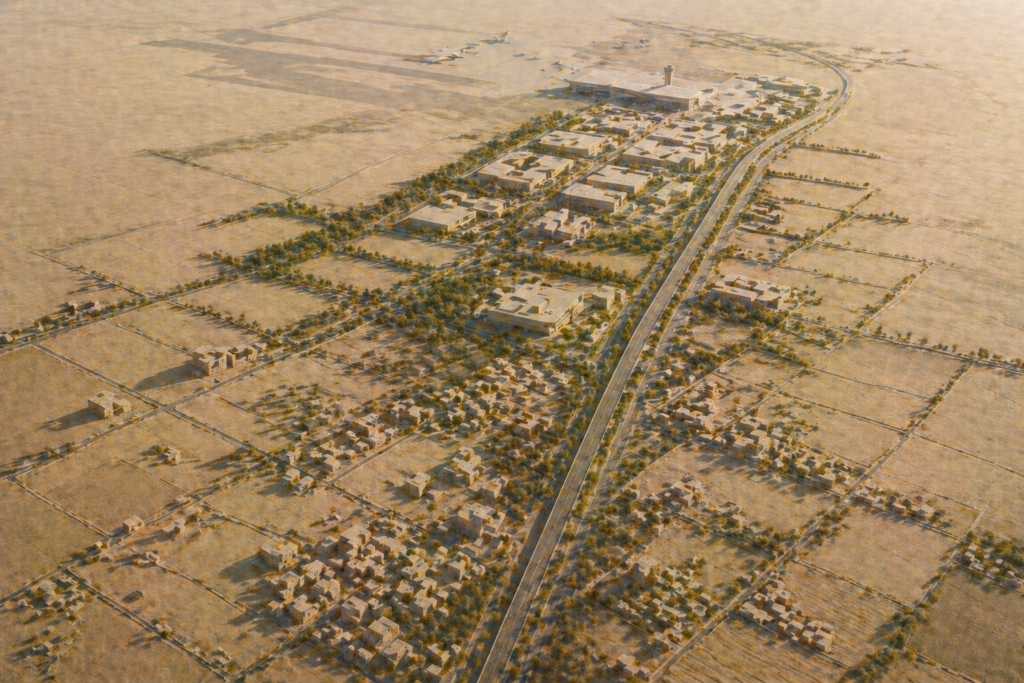
Our wider analysis of Bangalore’s peri-urban frontier identified the Sarjapur corridor as one of the most instructive examples in the metropolitan region of how agricultural landscape transforms into urban territory, and of what that transformation costs capital that participates in the process without adequate governance discipline. The Sarjapur corridor, extending from the Outer Ring Road intersection at Sarjapur Road southward and eastward toward Sarjapur town and into the adjacent Anekal taluk, has undergone a transformation across twenty years that created both substantial wealth and substantial capital destruction, often in consecutive transactions on the same parcels of land.
The corridor’s transformation is instructive precisely because it was not orderly. It was a negotiation conducted simultaneously on multiple fronts: between private capital and landowners whose title chains were complex, between developers and planning authorities whose approval timelines were unpredictable, between the corridor’s growth aspirations and the ecological constraints imposed by the lake and drainage network of the South Pinakini catchment, and between the infrastructure investment needed to support density and the administrative capacity to deliver it. Understanding what happened in Sarjapur provides the operational intelligence that prevents its failures from being repeated.
The System Mechanism
The Sarjapur corridor’s transformation was initiated by the extension of technology employment along the Outer Ring Road from the Marathahalli-Bellandur zone toward the Sarjapur Road junction in the early 2000s. As commercial development extended along the Outer Ring Road, residential development followed in the immediately accessible zones to the south and east, with Sarjapur Road becoming a primary residential corridor serving the technology workforce employed along the Outer Ring Road. The residential demand created land value appreciation in the agricultural villages along the Sarjapur Road alignment, attracting developer attention to land that had previously been valued purely for its agricultural output.
The land assembly phase that followed involved small developers and local intermediaries negotiating with the joint family landowners of the agricultural villages that lined the corridor: Bellandur, Haralur, Kasavanahalli, Carmelaram, and extending toward Sarjapur and Dommasandra. Each village presented the title complexity described in STALAH’s Pillar I series: joint Hindu family coparcenary ownership, PTCL Act-encumbered grant land from post-independence welfare schemes, Karnataka Land Reforms Act-restricted agricultural tenancy history, and survey settlement records that had not been maintained through the rapid administrative changes of taluk boundary revision and municipal incorporation.
DC conversion applications before the Anekal Taluk Deputy Commissioner’s office and layout approval applications before BBMP and BMRDA moved through administrative timelines that ranged from months to years depending on the completeness of documentation, the presence of objections from adjacent landowners or government departments, and the administrative capacity of the relevant offices at each point in time.
The Administrative and Physical System
The ecological constraint that most consistently affected Sarjapur corridor development was the network of lakes and drainage channels associated with the South Pinakini river system’s upper catchment. The villages of the corridor sit within or adjacent to the drainage basin that historically fed a sequence of agricultural tanks, including Varthur Lake and Bellandur Lake, which form part of the largest contiguous lake system within the metropolitan area. The National Green Tribunal’s orders addressing these lakes, including restrictions on development within buffer zones and prohibitions on direct discharge into the lake system, created retrospective constraints on corridor development that affected parcels whose original conversion and layout approvals predated the NGT’s orders.
BBMP’s incorporation of significant portions of the Sarjapur corridor villages in successive boundary expansions, including the major 2007 expansion that added 110 village panchayats, transferred regulatory authority over large areas of the corridor from gram panchayat administration to BBMP’s development control regime. This transfer changed the applicable development control regulations, the building plan sanction authority, and the Khata classification system for properties within the incorporated areas, creating administrative complexity for investors and developers who had acquired land under the gram panchayat regime and now found their approvals subject to BBMP’s more stringent requirements.
Infrastructure in the Sarjapur corridor developed primarily through private investment rather than through coordinated public infrastructure delivery. Internal road networks within residential layouts were formed by developers as conditions of layout approval. Water supply relied on private borewell extraction rather than BWSSB connection in most areas outside the BBMP boundary. This decentralised infrastructure model created development that was individually viable at the project level but collectively inadequate at the corridor level, with fragmented road connectivity, declining groundwater availability, and stormwater drainage systems that were designed for individual project boundaries rather than for the corridor’s aggregate runoff.
The Operational Consequence
The operational consequence of the Sarjapur corridor’s development pattern for real estate investors is a mixed quality landscape in which institutionally sound assets and legally deficient assets exist in close proximity, creating an information environment where superficial market assessment produces misleading conclusions about asset quality. A buyer who evaluates Sarjapur corridor assets on the basis of location within the corridor rather than on the legal quality of the specific parcel and the infrastructure provision of the specific development is accepting a risk profile that the corridor’s general appreciation trajectory does not reveal.
The water supply constraint that emerged as the corridor’s most persistent operational limitation was a consequence of the decentralised infrastructure model rather than of any fundamental hydrological inadequacy. The Deccan Plateau’s groundwater resources in the Sarjapur zone are not unlimited, and the extraction demands of a rapidly urbanised corridor without BWSSB supply infrastructure progressively depleted the aquifer levels that residential communities and commercial developments depended on. Communities constructed without sewage treatment plants and rainwater harvesting infrastructure faced escalating water supply costs as borewell yields declined and tanker supply became the primary source.
Developers who pre-sold residential units in Sarjapur projects before completing DC conversion, layout approval, and RERA registration created a class of buyer whose contractual rights were legally fragile and whose practical remedies were limited. The concentration of RERA complaints in the Sarjapur corridor reflects the pattern of governance failure described in STALAH’s capital discipline series: approvals sought after sales commenced, designated accounts improperly maintained, construction timelines extended beyond RERA commitments, and completion certificates deferred indefinitely.
The STALAH Interpretation
In practice we observe that the Sarjapur corridor’s transformation provides a case study in the difference between corridor-level value creation and asset-level value capture. The corridor as a geography created substantial value through its transformation from agricultural landscape to urban employment and residential zone. The capture of that value by individual investors was determined not by corridor selection, which was in retrospect clearly correct, but by the governance quality of each investor’s specific position: the completeness of title verification, the adequacy of holding capital relative to administrative timelines, and the discipline to acquire only positions whose legal foundation could support the development thesis.
A disciplined investor approaching any peri-urban corridor in Bangalore’s metropolitan region should treat the Sarjapur experience as an empirical record of what governance failure costs in a context where corridor-level value creation is real. The lesson is not that the corridor was a poor investment. The lesson is that corridor selection and governance discipline must both be present for capital to compound in the market that the corridor creates.
Over time the evidence suggests that the positions in the Sarjapur corridor that generated the most durable returns were those held by investors with deep legal verification capability, adequate patient capital, and the operational discipline to exit rather than proceed when governance complications were identified. These investors benefited from the same corridor appreciation as those who accepted governance risk, but they accumulated assets rather than litigation.
The Risk Ledger
NGT-imposed lake buffer revisions affect the Sarjapur corridor with particular force because of the density of tank and drainage features in the South Pinakini catchment within and adjacent to the corridor. Parcels whose DC conversion and layout approval preceded the current buffer definitions may carry approval rights that cannot be implemented under the current environmental framework without modification, creating a mismatch between the paper approval and the physical development potential that due diligence must identify.
Groundwater depletion continues to affect both the operational sustainability of existing developments and the feasibility of new developments that cannot access BWSSB supply. The Central Ground Water Authority has designated several zones within the Sarjapur corridor as over-exploited or critical, restricting new borewell construction and extraction. Developments without BWSSB connection in these zones face supply constraints that cannot be resolved through private infrastructure investment.
Revenue site proliferation in the corridor’s gram panchayat-origin areas creates a title quality gradient that is not transparent from location alone. Areas that were incorporated from gram panchayat to BBMP administration carry significant quantities of revenue site development whose B Khata classification and planning non-compliance are not apparent without specific administrative verification of each property’s Khata status and building plan sanction record.
STALAH Knowledge Graph Links
This analysis connects to the examination of lake catchments and development risk, which addresses the specific ecological constraint mechanism that has most significantly affected the Sarjapur corridor’s development economics. The treatment of groundwater risk in peri-urban Bangalore provides the hydrological framework for understanding the water supply challenge that decentralised infrastructure development in the Sarjapur zone has created. The examination of agricultural land fragmentation situates the title complexity of the corridor’s ancestral landholding pattern within the broader framework of inheritance-driven documentation deficiency.
Practical Audit Questions
Questions a disciplined investor should raise when evaluating Sarjapur corridor positions include: Has the position been assessed against the current BMRDA Master Plan 2031 designations and applicable NGT lake buffer orders, confirming that the development potential assumed in the investment thesis is achievable under the current environmental and planning framework. Has title verification extended to examination of PTCL Act grant records in the Anekal Taluk land grant register, confirming that no SC/ST grant history affects the parcels under consideration. What is the water supply arrangement for any completed or planned development, and does it include BWSSB connection or a certified combination of rainwater harvesting, treated water recycling, and BWSSB registration that is sustainable without dependence on declining borewell yield. Has the Khata classification of each property within the position been confirmed through direct engagement with BBMP’s property register rather than through vendor-provided documentation. Are there any pending RERA complaints, KRERA enforcement orders, or civil court proceedings against the developer or landowners involved in the transaction.
Related Reading
Frequently Asked Questions
Is Sarjapur still a good real estate investment in 2026, or has the price run already happened?
Sarjapur’s plot prices of ₹3,500-6,000 per sq ft reflect significant appreciation from its 2018-2020 base, but the ORR extension has not yet been delivered and GCC demand continues to strengthen. The corridor is mid-cycle rather than peaked — meaningful appreciation remains ahead for investors who can hold through the ORR commissioning event. However, price entry discipline is now essential; the margin for error on title and regulatory risk has narrowed as prices have risen, making thorough due diligence non-negotiable for any acquisition above ₹3 crore.
What infrastructure improvements have finally arrived in Sarjapur after years of delays?
Sarjapur’s internal road network has seen meaningful improvement through BBMP capital works since 2022. The Sarjapur Road widening from Agara junction to Carmelaram has progressed, reducing chronic congestion. However, the ORR extension connecting Sarjapur to the outer ring road remains the transformative infrastructure event the corridor has been anticipating for a decade. When commissioned, it will integrate Sarjapur with the established IT employment belt and trigger the corridor’s most significant appreciation phase.
What title issues are most common in Sarjapur real estate transactions?
The most common title issues in Sarjapur involve agricultural land sold without proper DC conversion, coparcenary inheritance disputes on family-held parcels informally partitioned across generations, gram panchayat layout approvals that predate BMRDA oversight and do not conform to BBMP standards, and lake buffer zone encroachments given the corridor’s significant lake density. A 30-year title search is the minimum; for agricultural-origin parcels, Form 7/12 and RTC verification tracing back to the last tenancy settlement is essential before any funds are committed.
Arpitha is the founder of Stalah, a principal-led real estate house shaped by clarity, discretion, and long-term thinking. Her approach focuses on selective mandates, thoughtful representation, and measured real estate decisions.
Related Reading: