Abstract
The peri-urban frontier of Bangalore represents one of the most frequently misinterpreted environments in the regional land market. Capital often treats the urban edge as a simple extension of the city, assuming that proximity to future growth automatically produces value. In practice the transformation of agricultural land into urban assets is neither linear nor predictable. It is a prolonged negotiation between rural governance systems, metropolitan planning authorities, ecological constraints, and infrastructure timelines.
We observe that the greatest vulnerability for capital at the edge of the city arises from jurisdictional friction. Land frequently sits between overlapping administrative structures including Village Panchayats, the Bangalore Metropolitan Region Development Authority, and specialized planning bodies such as BIAAPA. Municipal utilities may arrive a decade after private capital has entered the landscape. Environmental mandates governing lakes and drainage corridors impose constraints that many investors fail to anticipate.
The STALAH position is that land at the metropolitan frontier cannot be approached through speculative density models. Capital security is achieved through stewardship. Projects that respect the hydrology of the Deccan Plateau, anticipate infrastructure latency, and maintain ecological alignment are structurally more resilient than developments that attempt to impose urban intensity prematurely.
At the edge of Bangalore, capital must learn to operate at the pace of landscape rather than the speed of speculation.
Foundational Context
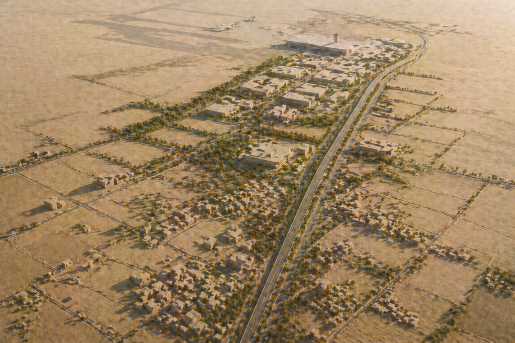
The outward growth of Bangalore has historically followed a pattern of gradual territorial absorption. Agrarian landscapes surrounding the historic city were slowly integrated into the metropolitan economy through transportation infrastructure, industrial development, and residential expansion.
For much of the twentieth century the administrative boundary of Bangalore remained relatively compact. Land beyond this boundary was governed through village institutions operating under the Karnataka Land Revenue Act. Agricultural cultivation, village settlement areas known as Grama Thana, and common lands structured the rural economy.
The emergence of the technology industry altered this spatial equilibrium. As employment centers expanded beyond the traditional Central Business District, development began to follow new infrastructure corridors. Whitefield, Electronic City, and the Outer Ring Road became the first generation of suburban urbanization.
Over time the pressure of urban growth pushed development further outward. Industrial corridors emerged across regions such as Hoskote-Narsapura, Jigani-Anekal, and the Devanahalli plateau. Residential layouts began appearing beyond the historic suburban ring.
However this outward movement did not occur within a unified governance framework. Land that physically appeared urbanizing often remained legally rural. Village Panchayats retained administrative authority even as land values rose dramatically due to metropolitan demand.
This created a zone of jurisdictional ambiguity at the metropolitan edge. Land could be situated within the economic influence of Bangalore while still operating under agrarian legal structures.
The BMRDA Master Plan 2031 and infrastructure initiatives such as the Satellite Town Ring Road represent attempts to introduce coherence across the broader metropolitan region. These frameworks establish the skeletal structure through which the next phase of expansion will occur.
Yet the landscape remains transitional. Municipal utilities such as BWSSB water networks and BESCOM power distribution rarely reach these zones immediately. Capital therefore enters an environment where rural ecological systems remain active even as urban expectations begin to shape land values.
Understanding this transitional condition is essential for disciplined investment at the frontier.
The System Architecture of the Peri-Urban Frontier
The metropolitan edge operates through the interaction of three structural systems.
The first system is jurisdictional governance. Rural land administration, metropolitan planning authorities, and environmental regulators all influence development rights.
The second system is ecological capacity. Soil permeability, watershed structure, and drainage corridors determine how the landscape absorbs development pressure.
The third system is infrastructure latency. Transportation corridors, electricity networks, and water supply systems often arrive years after initial capital deployment.
Urbanization occurs only when these systems align.
When development intensity exceeds ecological capacity, flooding and groundwater depletion emerge. When capital moves ahead of infrastructure, projects become dependent on expensive private utilities. When governance structures conflict, regulatory disputes interrupt development.
The frontier therefore behaves less like a conventional real estate market and more like a territorial negotiation between landscape, institutions, and capital.
The Determinants of Frontier Stewardship
Across the metropolitan edge four determinants consistently shape the durability of land investments.
Hydrological Integrity
Drainage corridors, watershed boundaries, and lake systems must remain functional to preserve land stability.
Jurisdictional Alignment
Land governed under coherent metropolitan planning frameworks experiences lower regulatory friction.
Infrastructure Timing
Transportation corridors and power networks determine the pace at which development becomes viable.
Development Intensity Discipline
Low density stewardship models often outperform speculative high density projects during early frontier phases.
These determinants transform land investment from speculative land banking into territorial stewardship.
Technical Framework
The regulatory architecture governing peri-urban land operates through a hierarchy of statutes and planning authorities.
The first layer arises under the Karnataka Land Revenue Act 1964. Agricultural land must undergo formal conversion before it can be used for non agricultural purposes. Section 95 governs this conversion process through the office of the Deputy Commissioner.
Conversion alone does not create development rights. Land use must also align with planning frameworks established under the Karnataka Town and Country Planning Act 1961.
Within the Bangalore Metropolitan Region these frameworks are implemented by authorities including:
- Bangalore Metropolitan Region Development Authority
- Bangalore International Airport Area Planning Authority
- Local planning authorities governing specific industrial corridors
The BMRDA Master Plan 2031 designates land use categories across the metropolitan region. Agricultural zones, ecological buffers, and green corridors remain restricted even after revenue conversion.
Environmental regulation forms another layer of the framework. Directives issued by the National Green Tribunal protect lakes and drainage networks across the plateau.
Stormwater channels known as Rajakaluves form an interconnected hydrological system. Buffer zones around these channels restrict development activity and determine the effective buildable footprint of land parcels.
Hydrology therefore becomes a determinant of capital valuation.
Infrastructure provision introduces further technical constraints. Municipal water supply and sewer networks often remain absent in frontier zones. Developments must rely on decentralized systems including sewage treatment plants, rainwater harvesting networks, and groundwater extraction.
These technical realities shape development feasibility long before architectural plans are drawn.
Strategic Interpretation
The rural to urban transition is frequently misunderstood by speculative capital.
Many investors treat peri-urban land as a temporary holding zone that will inevitably become dense urban territory. This assumption encourages development models that replicate the high rise patterns of the central city.
The evidence suggests that this approach frequently fails.
High density development requires extensive infrastructure networks including water supply, sewer treatment, transportation capacity, and electrical distribution. At the metropolitan edge these systems may not exist for many years.
Proximity therefore becomes a misleading metric.
Land located closer to the city may still lack the ecological or governance characteristics required for sustainable development.
We observe that the most resilient assets at the frontier are those that align development intensity with the ecological capacity of the site. Low density stewardship models allow natural drainage systems to remain functional and reduce pressure on groundwater resources.
Ecological integrity therefore becomes a form of capital security.
Land that retains functional hydrology and soil permeability remains adaptable as infrastructure eventually arrives.
The frontier landscape rewards investors who recognize that urban boundaries move slowly. Capital that aligns itself with this pace of transformation often outperforms speculative attempts to accelerate it.
The Risk Ledger
Operating at the metropolitan frontier exposes investors to several risks that rarely appear during early acquisition stages.
Jurisdictional Friction
Village Panchayat approvals may conflict with metropolitan planning frameworks such as BMRDA zoning regulations.
Infrastructure Corridor Notifications
Large projects such as the Satellite Town Ring Road may introduce land acquisition notifications affecting nearby parcels.
Village Level Litigation
Agricultural land frequently carries inheritance histories extending across multiple generations.
Water Table Depletion
Industrial groundwater extraction can reduce aquifer levels across peripheral zones.
Environmental Buffer Revisions
Changes in lake or drain buffer regulations can reduce the buildable footprint of land parcels.
These risks rarely appear in speculative land valuations but frequently determine long term asset viability.
Strategic Judgment
Successful investment at the urban edge requires a stewardship mindset.
Land selection should begin with an ecological audit rather than a financial model. Hydrological mapping must identify drainage corridors, watershed boundaries, and soil permeability before development concepts are considered.
Governance alignment represents the second pillar of disciplined investment. Land located within defined planning jurisdictions such as BIAAPA zones offers greater regulatory clarity than parcels governed solely through village administrations.
Infrastructure forecasting must also inform capital deployment. Corridors connected to major transportation investments such as the STRR or airport connectivity routes tend to experience more structured urbanization patterns.
Development intensity should remain compatible with the physical capacity of the land. Low density projects preserve groundwater recharge and reduce ecological stress during early urbanization phases.
Stewardship transforms land from a speculative commodity into a durable territorial asset.
The Knowledge Architecture of the Frontier
The principles described in this pillar article form the foundation for a broader examination of peri-urban systems within the STALAH Journal.
Supporting analyses explore topics including:
North Bangalore’s Land Transformation
The Sarjapur Corridor Expansion
The Hosur Spillover Economy
Agricultural Land Fragmentation
Village Governance and Land Records
Groundwater Risk in Peripheral Land
Lake Catchments and Development Risk
Solar Farming on Degraded Land
Water Stewardship on the Deccan Plateau
Each of these subjects expands upon the territorial dynamics described in this paper.
Closing Reflection
The edge of Bangalore represents the point where the city negotiates its future with the landscape that surrounds it.
Urban expansion moves through infrastructure investment and planning frameworks. Geography evolves through hydrology, soil formation, and ecological succession. These processes rarely operate at the same speed.
Investors operating at the metropolitan frontier must therefore decide which temporal framework they intend to respect.
Speculation assumes that the landscape will eventually accommodate urban ambition.
Stewardship recognizes that urban ambition must adapt to the landscape.
Over time this distinction becomes visible in the durability of the built environment. Developments that respect ecological systems continue to function with minimal intervention. Projects constructed in opposition to those systems encounter recurring regulatory and environmental challenges.
The future of Bangalore is not determined solely within its existing boundaries.
It is determined at the edge.
Related Reading
Frequently Asked Questions
What planning authority governs land just outside Bangalore’s BBMP boundary?
Land immediately outside the BBMP boundary falls under BMRDA (Bangalore Metropolitan Region Development Authority) jurisdiction for planning purposes, with gram panchayats functioning as the local body for building permissions in their respective village areas. BIAAPA governs the Devanahalli-Doddaballapur corridor north of Bangalore. BDA has layout approval authority within its notified planning districts. Investors must verify the applicable planning authority for any specific parcel, as building approval standards, setbacks, and permitted land use vary significantly across these jurisdictions.
How does gram panchayat land differ from BDA or BBMP approved land in Bangalore’s peri-urban areas?
Gram panchayat-approved layouts typically lack the road widths, drainage infrastructure, and utility provisions required under BDA or BBMP standards. GP approvals do not automatically confer home loan eligibility, and most banks decline to finance properties in GP layouts that have not been regularised or absorbed into BBMP. When areas are absorbed into BBMP, existing GP approvals are not automatically upgraded — properties may require Akrama-Sakrama regularisation or fresh BBMP compliance before they qualify for bank finance or RERA registration.
What ecological restrictions apply to land near Bangalore’s lakes and drainage corridors?
Karnataka’s Lake Buffer Zone Rules 2026, notified February 18, 2026, mandate setbacks of 0-30 metres from the lake boundary based on parcel size. Rajakaluve buffer zones require 7.5 metres each side for primary drains (15m total), 5 metres each side for secondary drains, and 2.5 metres each side for tertiary drains. The NGT has additionally imposed development moratoriums in parts of the Varthur and Bellandur watersheds. Any parcel within 500 metres of a mapped lake or rajakaluve requires mandatory buffer zone verification before purchase.
Peri-Urban Land Systems: Complete Reading List
- The Economics of Urban Expansion Corridors
- The Sarjapur Transformation
- The Devanahalli Corridor
- The Hosur Spillover Economy
- Agricultural Land Fragmentation
- Labor and Agrarian Land Markets
- The Economics of Land Conversion
- Groundwater Risk in Peri-Urban Bangalore
- Lake Catchments and Development Risk
- Biodiversity Corridors and Urban Expansion
- Infrastructure Lag in Emerging Corridors
- The Rural Governance Framework
- Ecological Carrying Capacity of the Plateau
- Rajakaluve Drainage Buffers and Development Risk
- Stormwater Drain Networks and Urban Flood Risk
Arpitha is the founder of Stalah, a principal-led real estate house shaped by clarity, discretion, and long-term thinking. Her approach focuses on selective mandates, thoughtful representation, and measured real estate decisions.
Related Reading: